The Secret Garden, Kemptown – key findings from research
• Yvonne Dale stated in her will that she wanted a plaque in the garden to commemorate Antony and for the garden to be call the Antony Dale Garden
• The current Secret Garden was part of a much larger garden belonging to no 32 Sussex Square
• All the gardens to nos 32-40 Sussex Square had a pleasure garden from the back of the house to Bristol Place and a larger piece of ground from the east side of Bristol Place extending down to Arundel Road.
• It is not clear when Bristol Place was built, whether concurrent with the houses being built or later – it is shown on the schematic plan for Kemptown (1826) where it is called Sussex Mews East and is shown with or without a name on town and OS maps from 1851 onwards
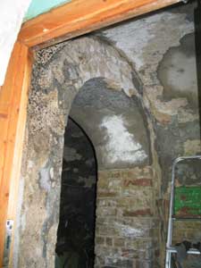
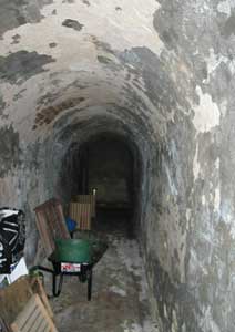
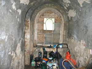
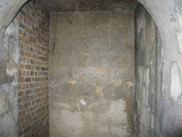
• The tunnel under Bristol Place which connected the smaller pleasure garden to the Secret Garden is not the only tunnel under Bristol Place – there are at least 4 others, one of which was behind no 36 where the pupils of the Lawrence sisters (who ran the precursor to Roedean School) “trooped through gas-lit tunnels to the great gymnasium” on the eastern side of Bristol Place. If you look behind Langhurst flats in Bristol Place you can see the drop in level from the road and also archways where some of the tunnels would have come out.
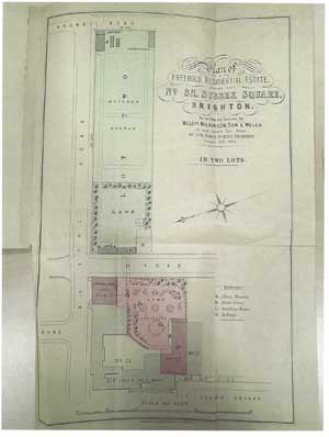
• The sale particulars for 32 Sussex Square (at auction) in 1900 outlines two separate plots for sale:
• The house and pleasure garden plus carriage house and stables all on the west side of Bristol Place (the carriage house and stables were on the corner of Bristol Place and Bristol Gardens)
• The remaining gardens stretching from Bristol Place down to Arundel Road. This was divided in two by the bugaroosh wall currently at the end of the secret garden. The secret garden end was a pleasure garden with a fives court in the SW corner, a “tennis lawn”, a Summer House, a smoking room (at the southern end of the existing building) a tool house and a w.c. The part beyond the wall is shown as a “large and productive walled-in kitchen garden. Well planted with fruit trees etc, vinery 29ft long, with hot water pipes, potting house and shed”. The buildings were at the Arundel Road end
• The conditions of sale required the purchases of Lot 1 and Lot 2 to block up the mouth of the tunnel by 9” thick brick walls within one month of completion
• A subsequent sale of the house in 1920 shows only the house and smaller pleasure gardens – the gardens to the east of Bristol Place were not included implying that the sale in 1900 did split the grounds into two lots
• The 1898 OS map (25” to 1 mile) does not show glasshouses in the kitchen garden to no 32 but by 1911 it is marked as a Nursery and the 1931 map shows extensive glasshouses there. They were still there in the 1953 map so when Antony Dale bought the Secret Garden in 1950 from the Baptist Union Corporation Ltd the original large garden was already in two parts and the old kitchen garden part (the other side of the bungaroosh wall) still had lots of glasshouses shown there – no development took place on that part until Rugby Court in 1972.
• I have not been able to find out full details of how/when the Baptist Union owned the secret garden land. The 1911 OS map shows a Gospel Hall on the corner of Bennet Road and Bristol Gardens (opposite the north side of the secret garden) so there may have been church owned lad nearby. The Gospel Hall must have been demolished in the first half of the 20th century as houses currently at the south end of Bennet Road were then built and the houses re-numbered and it doesn’t appear on subsequent OS maps of the area. A conveyance in 1928 of land currently occupied by Rugby Court to the Baptist Union contains a covenant relating to the area next to the bungaroosh wall suggests that at one stage the whole of the old kitchen garden for 32 Sussex Square was in the possession of the Baptist Union
• The first occupant of 32 Sussex Square was Laurence Peel, the younger brother of Sir Robert Peel, who lived there from 1830 until his death in 1888. He left the house to his son Charles Lennox Peel who sold it in 1892 to Lord Gardener whose family stayed there until 1900. The Roundell family were there between 1903 and 1920 and from 1924 onwards the house had multiple occupancy and was turned into flats. Antony Dale lived at no 46 Sussex Square between 1914 and 1962 but never lived at no 32. Antony Dale’s grandfather, Joseph Liddel had lived at no 46 since 1904.
( see House Histories/Sussex Square/No 32 for more information)
• Other well-known occupants of that section of Sussex Square included the Lawrence sisters (Penelope, Millicent and Dorothy) who founded Roedean School. They used nos 35, 36 and 37 Sussex Square as well as other houses nearby as part of Wimbledon House prior to moving to the current location of Roedean School in 1899.
( see House Histories/Sussex Square/No 35, 36 or 37 for more information )
Lady Sackville, Vita Sackville-West’s mother, owned no 40 between 1918 and 1923 and converted it into a palace for herself with the help of her friend Edwin Lutyens. She moved to White Lodge on the cliff (near to Roedean School) having commissioned Lutyens to enlarge and re-model the house and gardens to her own needs (it is HE listed).
( See House Histories/ Sussex Square/No 40 or Articles/ Lutyens drawings for 40 Sussex Square, for further information )
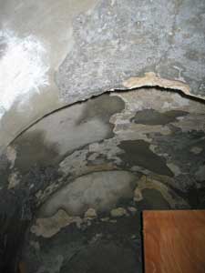
• I have looked more closely at the walls surrounding the secret garden with my husband Chris, who has worked for 50 years in construction. Whilst there have been question marks raised over the validity of the HE listing I have seen evidence to suggest that they are the original William Ranger patented stone. The wall facing Bristol Place is mostly rendered with modern rendering but round the corner in Bristol gardens you can see more of the underlying blockwork. The dimensions match those described in the Architectural Magazine article of 1835 and are too large for modern construction methods. Much of the original face has been eroded but areas close to the ground and higher up show what the original face of the blocks might have looked like with the adjacent mortar lines. It is not dissimilar to Portland Stone which the originator was aiming for. The coping (top of the wall) does not use modern construction methods indicating it is of some age. The existing wall on the south side of the secret garden goes all the way down to Arundel Road (you can see it from Sussex Square Mews and from Arundel Road end). This is consistent with it being the original “wall surrounding the garden of Mr Peel” built by William Ranger. It would be possible to get part of the stonework tested by a specialist company to identify component parts and hence to age it. If you are interested in going down this route I can get a contact for you.
• You can see the rear side of the “bungaroosh” wall at the end of the Secret Garden from the side entrance to Rugby Court and you can clearly see the archway near the Bristol Gardens end where the door through from the pleasure garden to the kitchen garden went as shown on early maps. Indications are that this wall, which features on all early maps of the area onwards, is original ie from 1830s.
• There have been various street name changes in the area which need to be taken into account when looking at historical maps. The far end of Eastern Road used to be called York Street. Bristol Gardens was originally called Sussex Street, then Bristol Road and then changed to Bristol gardens in 1898.
Pat Dauncey
February 2016